Jewel Basin sits in the Swan Range on the east side of the Flathead Valley, a pocket of alpine lake country that’s been set aside for one thing only: hiking on your own two feet. No mountain bikes grinding up the switchbacks, no pack strings on the trail, no engine noise drifting across the water. For a piece of country this close to a lake as busy as Flathead, that’s a genuinely unusual arrangement, and it’s the reason people drive the steep forest road up from Bigfork in the first place.
This guide covers what the basin actually is, which lakes and trails are worth knowing by name, how to get there from the Flathead Lake area, and what to plan around before you go.
What Jewel Basin is, and why it’s hiker-only
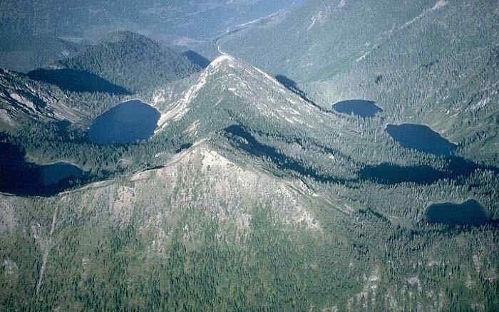
Jewel Basin Hiking Area is a roughly 15,000-acre parcel of the Flathead National Forest at the north end of the Swan Range, tucked between the Flathead Valley to the west and the Hungry Horse Reservoir drainage to the east. It holds 27 named lakes and about 35 miles of maintained trail, all threaded through subalpine forest, open basins, and rocky ridgelines that top out at Mount Aeneas, the highest point in the area at roughly 7,510 feet.
The hiker-only designation dates to 1970, when the Forest Service set the area aside specifically to keep it free of motorized use, mountain bikes, and horses or other pack stock. That rule applies across the entire hiking area, not just near the trailhead — it’s a blanket restriction written into the Forest Service’s regulations for the site, not an informal custom. The result is a trail network that feels smaller and quieter than its lake count would suggest, since every visitor is moving at the same walking pace and nobody is sharing tread with wheels or hooves.
That combination — real alpine scenery, genuinely close to a major lake, reachable without technical climbing — is fairly rare for this part of Montana, and it’s why Jewel Basin has a loyal following among Flathead Valley hikers even though it doesn’t get the name recognition of Glacier National Park an hour up the road.
Named trails and lakes worth knowing
With 27 lakes scattered across the basin, most visitors aren’t trying to see all of them in one trip — they’re picking a handful reachable from Camp Misery and building a day, or a short overnight, around those.
The most popular single outing is the loop over Mount Aeneas and down to Picnic Lakes, following trails numbered #717 and #392 from the trailhead. The climb out of Camp Misery gains elevation quickly through a series of switchbacks before reaching a ridge that leads up to the Aeneas summit, where the Flathead Valley and the lake open up below. From there, the trail drops to Picnic Lakes, a shallow pair of lakes that’s a common turnaround point or lunch stop before heading back down.
Farther into the basin, Blackfoot Lake and Black Lake sit along a string of smaller connecting lakes, and Birch Lake and Crater Lake are two of the more heavily visited backcountry lakes, each with a pit toilet — a sign of how much traffic they see relative to the rest of the basin. Twin Lakes is another commonly named destination on the same general network of trails. One notable lake in the basin, formerly carrying a name now recognized as a slur against Indigenous women, was renamed In-thlam-keh Lake in 2008 after a proposal from the Confederated Salish and Kootenai Tribes — an Anglicized rendering of the Salish word for black bear.
Farther south in the Swan Range, trail #21 leads to Bond and Trinkus Lakes, a route more often used by people approaching from that end of the range than from Camp Misery.
The basin also connects into a much longer route: the Alpine Trail #7 runs the crest of the Swan Range for more than 50 miles, and its northern reach touches the western edge of Jewel Basin — including Columbia Mountain, described in this site’s own guide to that trail. Almost nobody hikes the full connection in one trip from Camp Misery, since the two trailheads sit a considerable drive apart, but it’s worth knowing the basin isn’t an isolated pocket of trail — it’s one end of a genuinely long ridge system.
None of this is a complete list — with 27 lakes and 35 miles of trail, a lot of the basin is quieter water reached by routes that don’t show up in every trip report. But Mount Aeneas, Picnic Lakes, Blackfoot Lake, Black Lake, Birch Lake, and Crater Lake are the names that come up most often, and they’re a reasonable starting point for planning a first visit.
Getting there from the Flathead Lake area
Jewel Basin sits northeast of Bigfork, up out of the Flathead Valley on a forest road that does almost all of the climbing for you before your boots ever hit dirt. From Bigfork, the route runs north on Highway 35 to Highway 83, east on Highway 83 to Echo Lake Road, and then north on Echo Lake Road to the junction with Jewel Basin Road — Forest Service Road No. 5392 — which climbs roughly 2,500 vertical feet above Bigfork and Flathead Lake to reach the Camp Misery Trailhead.
That last stretch is the part to plan around. The road is steep, narrow, and unpaved for its final miles, with switchbacks that make low-clearance vehicles and anything towing a trailer a poor match for the drive. It’s a manageable trip for most passenger vehicles in dry conditions, but it’s not a road to take fast, and it’s worth allowing more time for the drive up than the mileage alone would suggest.
There’s no other realistic way into the hiking area’s interior — no lake-access trail, no shortcut from the valley floor. Camp Misery is the starting point for the large majority of hikes into the basin.
When to go and what to bring
July through September is the reliable window for Jewel Basin. At elevations that reach past 7,000 feet, snow can linger around the higher lakes and shaded trail sections well into early summer in a heavy snow year, and the access road itself may not be reliably clear until the same general window opens up. Late summer brings the most dependable trail conditions, along with a higher chance of afternoon thunderstorms building over the Swan Range — worth watching for on any day that starts clear, especially above treeline near Mount Aeneas.
Because the elevation gain happens mostly on the drive up rather than on the trail, a lot of Jewel Basin’s hikes start you out already above 6,000 feet, which means weather can turn colder and windier here than conditions in the Flathead Valley below would suggest. Layers, a wind shell, and sun protection are worth carrying even on a day that looks warm from the valley floor.
Water is generally available from the basin’s many lakes, but it should be treated or filtered like any other backcountry water source. There’s no store, water fill station, or ranger station at Camp Misery — pit toilets exist at the trailhead and at Birch and Crater Lakes, and that’s the extent of the built infrastructure anywhere in the basin. A paper map or downloaded offline map is worth having, since the trail junctions around the lake network aren’t always self-explanatory, and cell coverage at this elevation and distance from the valley is not something to count on.
Dogs are welcome but must stay leashed and under control on every trail in the basin — this is written into the same regulations that keep the area free of bikes and stock, not an informal courtesy. Group sizes are capped at 12 people per party, a rule aimed at keeping impact manageable on trails and lakeshores that see heavy summer traffic relative to their size.
Frequently asked questions
Is Jewel Basin really closed to bikes and horses?
Yes. Jewel Basin has been managed as a hiking-only area since its designation in 1970, and Forest Service regulations prohibit motorized vehicles, mountain bikes, and horses or other stock across the entire hiking area. Foot traffic only, on every trail in the basin.
Where does the main trailhead start?
Most hikers start at the Camp Misery Trailhead, reached via Forest Service Road No. 5392 (Jewel Basin Road), which climbs off Echo Lake Road east of Montana Highway 83. It's the primary access point into the basin and where most of the named trails begin.
How many lakes are actually in the basin?
Jewel Basin contains 27 named lakes across roughly 15,000 acres, though not all of them sit directly on maintained trail. Picnic Lakes, Blackfoot Lake, Black Lake, Birch Lake, and Crater Lake are among the ones most commonly reached from Camp Misery.
Is there a fee or permit to hike in Jewel Basin?
No day-use fee or permit is listed for entering the hiking area itself. Because requirements can change, it's worth checking current Flathead National Forest guidance before a trip, especially if your route involves overnight camping.
Can I bring my dog?
Dogs are allowed, but Forest Service regulations require them to be leashed and under physical control at all times on every trail leading into and within the basin — this isn't an off-leash area even on quiet stretches of trail.
What's the highest point in Jewel Basin?
Mount Aeneas, at roughly 7,510 feet, is the highest peak in the hiking area and the most popular summit, usually climbed as part of a loop that also visits Picnic Lakes on trails #717 and #392.
When is the best time to hike Jewel Basin?
July through September is the reliable window. Snow can linger on the higher trails and around the lakes well into summer in a heavy snow year, and afternoon thunderstorms are common in mid and late summer at this elevation.
Can I camp overnight at the lakes?
Backcountry camping is permitted in much of the basin, but campfires are banned within 500 feet of Birch, Crater, Twin, and Picnic Lakes to protect heavily used shoreline. Pit toilets are available at Camp Misery, Birch Lake, and Crater Lake, but there's no other infrastructure — pack out what you bring in.