Flathead Lake looks, from a map, like an easy place to paddle: a big, calm-looking blue shape ringed by mountains, with towns and public access scattered around its edge. On a still morning that’s exactly what it is. By early afternoon on the same day, the same stretch of water can be running whitecaps that would flip an unprepared kayak in minutes. Both of those descriptions are true, often on the same day, and understanding why is the real starting point for kayaking here — more useful than any list of put-ins on its own.
This guide covers the practical geography of sea kayaking Flathead Lake: where people actually launch, how the lake’s size and shape create its wind pattern, what the open crossing to Wild Horse Island really involves, and the cold-water safety basics that matter more here than on a small local pond. It’s written for paddlers bringing their own boats or renting locally, not for anyone looking for a guided tour.
Why the wind matters
Flathead Lake is the largest natural freshwater lake west of the Mississippi River, a long, deep basin sitting at the southern end of the Rocky Mountain Trench — the same great geological fault-line valley that runs north through British Columbia into the Yukon. The lake stretches close to thirty miles from its north end near Somers and Bigfork to its south end at Polson, and it’s wide enough in places that the far shore can disappear into haze on a hot afternoon. That size is exactly why wind behaves the way it does here.
A lake this large generates its own local weather. As the surrounding mountains and land heat up through the day, air moves across the open water and tends to build through the afternoon, funneled and amplified by the trench the lake sits in. The pattern isn’t identical every day — some mornings stay glassy well into the afternoon, and some days bring wind early — but building afternoon wind on the open water is a widely reported and genuinely common pattern here, not a rare event. Local sailors, who depend on exactly this wind, plan around it; paddlers, who are far more exposed to it, need to plan around it even more carefully.
The practical result is standard local wisdom repeated by paddlers, sailors, and lake residents alike: get your open-water miles in during the morning, and be back near shore, or at least somewhere you can bail out easily, before the wind has a chance to build. This matters far more on the open central and southern basin — the stretch of lake with the most fetch, the longest uninterrupted run for wind to build waves — than it does tucked into a sheltered bay near a town. A kayak that’s stable and manageable in a light morning breeze can become genuinely dangerous once a few miles of open water start producing sustained whitecaps, because unlike a sailboat, a kayak sits low, has almost no freeboard, and depends entirely on the paddler’s own strength and balance once conditions turn.
None of this means the lake is off-limits to paddlers. It means the lake rewards planning around its size rather than treating it like a smaller, calmer body of water. Check a real wind forecast the night before and again the morning of a trip, favor routes that keep you close to a bail-out shore, and build in enough time to be done with any open-water crossing well before the afternoon wind window typically opens.
Where to launch
Flathead Lake’s shoreline is a mix of small towns, private land, and public access points, several of which sit inside Flathead Lake State Park — a park managed not as one contiguous unit but as several separate units scattered around the lake’s edge, on both the east and west shores. Three of those access points come up again and again for paddlers: Somers, Yellow Bay, and Big Arm.
Somers
Somers sits at the lake’s north end, where the Flathead River empties in before continuing south the length of the lake. It’s one of the longest-established towns on the lake and functions as a natural access point for paddlers based in the northern Flathead Valley. The water close to Somers tends to be more sheltered than the open central and southern basin, simply because the north end narrows and the surrounding shoreline breaks up fetch. That makes it a reasonable place for a shorter, shoreline-hugging paddle, or for getting a feel for the lake’s character before committing to longer open-water days further south. It is not, however, a jumping-off point for reaching Wild Horse Island — the island sits well to the south, off the west shore.
Yellow Bay
Yellow Bay lies partway down the lake’s east shore and is one of the smaller Flathead Lake State Park units, with public lake access and a shoreline worth paddling in its own right. It’s also home to the Flathead Lake Biological Station, a University of Montana research facility that has operated on this stretch of shore for more than a century, studying the lake’s freshwater ecology. You won’t need to interact with the station to paddle nearby, but its long presence here is part of what makes Yellow Bay a well-documented, well-established stretch of shoreline rather than an obscure pull-off. As an east-shore launch, Yellow Bay puts you on the opposite side of the lake from Wild Horse Island and the Big Arm crossing — it’s better suited to exploring the east shore’s coves and bays than to reaching the island.
Big Arm
Big Arm sits on the lake’s west shore, south of Somers and north of Polson, and is both a Flathead Lake State Park unit and the standard mainland launch point for paddlers heading out toward Wild Horse Island. It has a boat launch and recognized public access, which is a meaningful part of why it functions as the jumping-off point for the crossing rather than some other stretch of west shore: a maintained, known launch matters when you’re about to commit to open water. Big Arm’s position also puts it closer to the lake’s wider southern basin, so paddlers launching here should treat wind planning as even more important than at a more sheltered northern launch.
Beyond these three, other Flathead Lake State Park units exist around the lake — Wayfarers and Finley Point on the east shore, the West Shore Unit on the west — and they’re worth exploring on their own terms. (Somers itself isn’t one of the park’s six units; Somers Beach is a separate, independently managed Montana state park at the same town.) Somers, Yellow Bay, and Big Arm simply come up most often for paddlers because they combine reliable public access with distinct, useful character: a sheltered northern town, a research-station east-shore bay, and the real launch point for the lake’s signature open-water crossing.
The crossing to Wild Horse Island
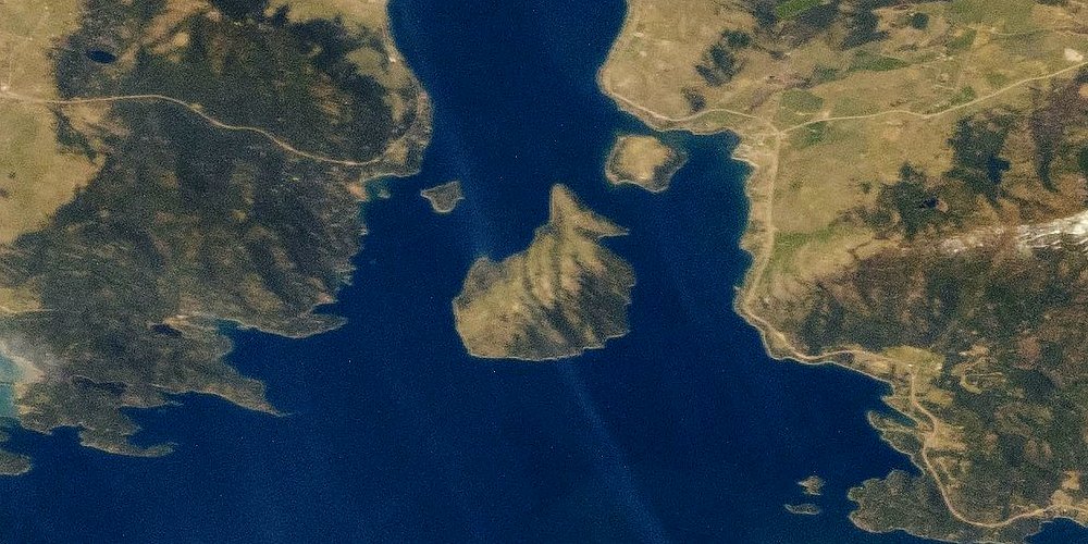
Wild Horse Island is the largest island on Flathead Lake, a state park unit in its own right, and the most talked-about paddling destination on the lake — for good reason. It’s a genuinely wild-feeling place in the middle of a lake otherwise ringed by towns and vacation homes, with bighorn sheep, mule deer, nesting bald eagles, and a small band of horses descended from herds once kept there by the Salish and Kootenai people. It’s accessible only by boat, which for a paddler means a real open-water crossing, not a short hop across a sheltered channel.
The shortest practical crossing runs from the Big Arm area, commonly described as roughly two miles of open water depending on exactly where you launch and land. Two miles is not a long distance for an experienced paddler on flat water, but it’s worth being honest about what “open water” means here: there’s no shoreline to duck into partway across, no shortcut if conditions change, and the crossing sits on the part of the lake most exposed to the wind pattern described above. A crossing that takes twenty calm minutes in the morning can become an hour or more of hard, wave-fighting work if wind builds while you’re on the water — and turning back at that point can be just as exposed as continuing.
This is a trip for paddlers who are comfortable reading open water, who check a real wind forecast rather than just looking at the sky from shore, and who are honest about their own skill level and their kayak’s stability in wind and chop. It is not the place to test open-water paddling for the first time. If you’re newer to the sport, the sheltered shoreline paddling near Somers or Yellow Bay is a better place to build that experience before attempting the crossing.
Once you’re on the island, it’s still Flathead Lake State Park land with its own rules about where landings and hiking are appropriate, in part to protect the wildlife that makes the island worth visiting in the first place. A separate, full guide to Wild Horse Island — covering the island itself in more depth, including its wildlife, trails, and what to expect once you’re ashore — exists elsewhere on this site for paddlers planning a visit beyond the crossing itself.
Cold water and safety
Flathead Lake is deep — deep enough, at its maximum, to stay cold well below the surface even in the height of summer, and its water is fed substantially by snowmelt and glacially influenced tributaries. In the warmest stretch of summer, shallow, sheltered bays can warm into genuinely comfortable swimming temperatures. That surface warmth can be misleading. A capsize in open water, away from a warm shallow bay, or a trip taken outside of peak summer, can put a paddler into water cold enough to bring on hypothermia and to sap swimming strength within minutes — long before exhaustion or distance to shore becomes the limiting factor.
The single most effective response to that risk is also the simplest: wear a properly fitted life jacket the entire time you’re on the water, rather than stowing one and planning to put it on if things go wrong. Cold water saps fine motor control and grip strength fast, and getting a jacket on and secured after an unexpected swim is far harder than it sounds from dry land. On sheltered, close-to-shore paddling this is still good practice; on an open crossing it is close to non-negotiable.
Beyond the life jacket, a few other habits matter on a lake this size. Check a real wind and weather forecast before you launch, not just current conditions, since the whole point of the afternoon wind pattern is that it changes through the day. Carry a way to signal for help — a whistle at minimum — and a way to call for help that doesn’t depend on a phone surviving a swim. Leave a basic plan with someone on shore: where you’re launching, roughly where you’re headed, and when you expect to be back. And build in a real safety margin on timing, especially for any open crossing, so that an unexpected slow stretch doesn’t leave you racing worsening wind back to shore.
Flathead Lake also carries meaningful boat traffic in summer, from small fishing boats to sailboats to large power boats near marinas and towns. A kayak sits low in the water and can be genuinely hard to spot from a faster boat, so staying visible, predictable, and clear of marked channels and busy marina approaches is worth building into a route alongside the wind planning.
It’s also worth knowing, before you launch anywhere on the lake, that Montana requires watercraft — including non-motorized kayaks, canoes, and paddleboards — to stop at open aquatic invasive species inspection stations. The requirement exists to protect the lake and the wider Flathead Basin from invasive mussels and other species that can spread on wet gear, and it applies whether you’re a Montana resident or visiting with your own boat. It’s a quick stop where a station is operating, and it’s the law, not a suggestion.
Reading conditions and planning a route
Because so much of the risk on Flathead Lake comes down to wind rather than current or rapids, the most useful skill a paddler can bring is simply reading conditions honestly, before and during a trip. A calm-looking surface near shore in the early morning tells you almost nothing about what the open central basin will look like by noon. Checking an actual wind forecast — not just glancing at the sky — the night before and again the morning of a launch is worth more than any single piece of gear.
Route planning benefits from the same honesty. A loop that hugs the shoreline the entire way, with frequent points where you could land if conditions changed, is a fundamentally different trip from a straight-line open crossing with no bail-out option partway across. Both are legitimate ways to spend a day on Flathead Lake, but they call for different levels of experience, different margins of error, and different answers to the question of what happens if the wind arrives early. Paddlers new to the lake, or new to open water generally, do well to start with shoreline routes near Somers or Yellow Bay and build a feel for how the lake’s wind actually behaves before committing to a crossing like the one to Wild Horse Island.
It also helps to think in terms of exposure rather than distance alone. A two-mile paddle tucked inside a sheltered bay and a two-mile open crossing are not the same trip, even though the number on a map looks identical. The open crossing has more fetch working against you, less shelter if wind builds, and fewer places to change your mind partway through. Judging a route by how exposed it is to the open lake, not just by how many miles it covers, is a habit that scales well from a first Flathead Lake trip to a much more experienced one.
Group paddling adds another layer of margin. A solo paddler on open water has no one to help right a capsized boat, spot a hazard, or go for help if something goes wrong; a small group, paddling within sight and earshot of each other, has real options in a way a solo paddler doesn’t. That’s not a reason to avoid solo paddling on the lake’s more sheltered stretches, but it’s a real factor to weigh before a solo open-water crossing.
When to go
The realistic paddling season on Flathead Lake runs from roughly June through September, the stretch when both air and water temperatures make a full day on open water comfortable rather than punishing. Within that window, July and August tend to bring the warmest water and the most stable stretches of weather, which is part of why they’re the busiest months for boat traffic of every kind — another reason to plan routes with visibility and boat lanes in mind.
Shoulder-season paddling, in late May, early June, or into late September, is possible for well-prepared, experienced paddlers, but it comes with real trade-offs: colder water, more variable weather, and often less boat traffic to watch for but also less help nearby if something goes wrong. Afternoon wind isn’t strictly a summer phenomenon either — it can show up across the paddling season — so the morning-launch, early-finish approach holds regardless of the month.
Whatever the season, checking conditions the morning of a trip, rather than relying on a plan made days earlier, is the single habit that does the most to keep a Flathead Lake paddle in the “memorable” category rather than the “cautionary” one.
Beyond the lake
Kayaking Flathead Lake is one piece of a larger, connected water landscape in this part of Montana. The Flathead River itself flows into the lake’s north end near Bigfork and exits again at the south end near Polson, and paddling the river — whether a gentle float or a whitewater stretch upstream — is its own distinct undertaking, with different current, different hazards, and its own access points, covered separately elsewhere on this site. Multi-day trips that combine stretches of river and lake are possible for paddlers with the experience and logistics to plan them, and gear considerations — what to bring, what to rent, and how lake gear differs from river gear — are also covered on their own.
Treat this guide as the lake-specific piece of that bigger picture: the geography of Somers, Yellow Bay, and Big Arm as launch points, the real character of the Wild Horse Island crossing, and the wind and cold-water realities that shape a safe day out, whichever stretch of shoreline you start from.
Flathead Lake Kayaking: Best Spots Sea Kayak Guide, Quick Facts
A short summary for anyone comparing Flathead Lake kayaking against other Montana lakes: this guide treats sea kayak paddling here as open-water travel, not a sheltered pond outing, because the wind genuinely earns that caution. For the best spots guide shorthand — Somers and Yellow Bay for shoreline miles, Big Arm for the Wild Horse Island crossing — see the sections above. People searching for sea kayaking Flathead Lake usually mean exactly that Big Arm crossing, and it’s the single most asked-about stretch on this whole guide. If you’re weighing kayaking Flathead Lake Montana options against a guided tour, the honest answer is that any of the three launches works for a self-guided sea kayak day, provided you respect the afternoon-wind rule above. This best spots guide will keep steering beginners toward Somers and confident paddlers toward the Big Arm sea kayak crossing. Flathead Lake kayaking rewards patience with the forecast far more than it rewards an early start alone — check the wind before you check the launch time. That’s the whole of kayaking Flathead Lake Montana in one sentence: go when it’s calm, not just when you’re ready.
Frequently asked questions
Is Flathead Lake a good place for a beginner kayaker?
The sheltered coves near Somers and the shoreline around Yellow Bay are reasonable places to start, since you can hug the shore and turn back quickly if wind or waves pick up. The open crossings — especially anything heading out toward Wild Horse Island — are a different proposition and are better suited to paddlers with some open-water experience and a rescue plan.
How far is the paddle to Wild Horse Island?
The shortest crossing, from the Big Arm area, is commonly described as roughly two miles of open water, though the exact distance depends on exactly where you put in and land. Two miles sounds short on paper, but on a big, wind-exposed lake it can take much longer than expected once waves and headwinds enter the picture.
What do I do if the wind picks up in the middle of a crossing?
Stop paddling toward your original destination and reassess immediately — the nearest safe shore, not your planned landing, is now the goal. Angle your bow to take waves at a manageable angle rather than broadside, keep your weight low and centered, and be willing to turn back the way you came if that shore is closer than the far side.
How cold is the water?
Flathead Lake is deep and glacially fed, and it stays cold even when the surface has warmed. Sheltered, shallow bays can reach comfortable swimming temperatures in July and August, but a capsize away from shore, or in spring and fall, can put you in water cold enough to bring on hypothermia and impair swimming within minutes.
Do I need a life jacket, or is it enough to just carry one?
Wear it, don't just carry it. Cold-water immersion can take away useful arm and hand strength within minutes, which makes putting on a stowed life jacket after a capsize far harder than it sounds. On open, wind-exposed water this isn't a suggestion — it's the single most effective thing a paddler controls.
Do I need a permit to kayak on Flathead Lake?
No permit is required for recreational, non-commercial kayaking on the lake itself. You do need to stop at any open watercraft inspection station you pass, since Montana requires an aquatic invasive species check for all watercraft, including kayaks and paddleboards, launching on or moving between the state's waters.
Is it better to rent a kayak or bring my own?
Either works. Bringing your own means you know the boat and its fit, which matters more on open water than on a sheltered pond. If you rent, ask specifically about the make and stability of sea kayaks versus recreational kayaks, since the wider, shorter recreational boats common at rental counters are not well suited to wind and open-water chop.
What's the best time of day to paddle?
Morning, by a wide margin. The lake is frequently calm at sunrise and stays manageable through the early hours, then wind tends to build through the day, especially on the open central and southern basin. Planning to be off open water — or at least close to shore — by early-to-mid afternoon is the standard local approach.
What time of year is best for kayaking Flathead Lake?
Roughly June through September covers the season when air and water temperatures make a full day on the lake comfortable. July and August bring the warmest water and the most stable weather windows, though afternoon wind and occasional thunderstorms are a summer-long risk, not just a spring or fall one.
Can I paddle from Somers?
Yes. Somers sits at the north end of the lake and has long served as a common access point, with more sheltered water close to town than you'll find on the open central lake. It's a reasonable base for shorter, shoreline-hugging paddles rather than a launch point for the Wild Horse Island crossing, which is done from the west shore.
What is Yellow Bay known for besides paddling?
Yellow Bay is home to the University of Montana's Flathead Lake Biological Station, a freshwater research facility that has operated on the east shore for well over a century. The bay itself is also a Flathead Lake State Park unit with lake access, making it a natural stop for a shoreline paddle on the east side.
Why do people launch for Wild Horse Island from Big Arm specifically?
Big Arm is the closest state park unit on the mainland to Wild Horse Island, which makes it the shortest realistic open-water crossing to the island. It has a boat launch and is a recognized access point, which is why it's the standard jumping-off point rather than paddling from further up or down the west shore.
Can I camp or land anywhere I want on Wild Horse Island?
No. Wild Horse Island is state park land with its own rules on where you can go ashore and what's allowed once you're there, and it supports wildlife, including bighorn sheep and a small band of horses, that can be disturbed by careless landings. Check current Montana State Parks guidance for the island before you plan a landing, rather than assuming general lake rules apply.
Do the rules change on the southern half of the lake?
Yes, in the sense that the southern half of Flathead Lake lies within the Flathead Indian Reservation, under the jurisdiction of the Confederated Salish and Kootenai Tribes. That doesn't close the water to paddlers, but it does mean some regulations and permit requirements on land and adjoining waters can differ from the north end, so it's worth checking current CSKT guidance if your trip includes that area.
What safety gear should I actually bring, beyond a life jacket?
A whistle or other sound signal, a way to call for help that doesn't depend on a wet phone screen, a bilge pump or bailer, and enough warm, non-cotton layers to handle a sudden temperature drop. A basic float plan left with someone on shore — where you're going and when you expect to be back — costs nothing and matters more than most gear.
Is Flathead Lake affected by boat traffic?
Yes. It's a large, popular lake with significant motorboat and sailboat traffic in summer, particularly near towns and marinas. Kayaks sit low and can be hard for faster boats to see, so staying visible, predictable, and away from marked channels and marina traffic lanes is worth building into any route.
Where does the Flathead River fit into a lake-kayaking trip?
The Flathead River flows into the lake's north end near Bigfork and back out at the south end near Polson, and paddling the river itself is a separate kind of trip from open-lake kayaking — different current, different hazards, and its own put-ins and take-outs. It's covered on its own elsewhere on this site rather than folded into a lake guide.