Stanton Lake is one of the shortest genuinely worthwhile stops along this stretch of U.S. Highway 2 — a lake you can reach, sit with for a while, and be back at the car for well inside an afternoon, without the trail ever wandering far from the highway corridor it starts on. It sits in the Flathead National Forest on the edge of the Great Bear Wilderness, directly across the road from Glacier National Park, and it draws a steady stream of travelers looking for one solid stop between longer drives rather than a full day’s commitment.
None of that makes it obscure. Stanton Lake is a well-known, well-used trail, and its combination of a short approach and a real payoff at the end — clear, glacier-fed water sitting directly below a named mountain — is exactly why it shows up on so many Highway 2 trip lists. This guide covers the actual trail conditions, what’s visible once you’re standing at the shore, how to get there from the highway and from Flathead Lake, and when the route is realistically open.
The trail itself
The route is officially Trail #146 in the Flathead National Forest system, and it earns points for honesty: it does what a short, well-marked forest trail is supposed to do, without surprises. Different sources describe its length a little differently — some list the walk to the lake at around one and a half miles each way, others closer to two — which works out to somewhere in the three-to-four-mile range round trip. That variation isn’t a sign of bad information so much as different measuring points; the Forest Service’s own figure for Trail #146 runs considerably longer than that because the trail keeps going well past the lake, continuing up the Stanton Creek drainage toward terrain used by climbers approaching Great Northern Mountain. That upper section is a different, much more serious undertaking than the walk to the lake, and this guide is only concerned with the latter.
Elevation gain estimates for the lake segment vary in the same way, from roughly 250 feet on the low end to a bit over 700 feet on the high end, but the shape of the climb is consistent across every account: the trail is steepest in its first half-mile to full mile out of the parking area, then the grade eases substantially, and the final stretch down to the shoreline is close to flat. That front-loaded structure is worth knowing before you start, since the trail can feel more demanding in its opening minutes than the rest of the hike will suggest.
About a mile in, the trail meets a junction with the Grant Ridge Trail, which splits off toward a much steeper climb into higher country. Staying on the main trail at that junction keeps you on the route to Stanton Lake; the branch is a separate, harder trip for a different kind of day. The trail corridor itself runs mostly through mixed conifer forest along Stanton Creek, with enough shade to make it a comfortable option even on a hot midsummer afternoon, and parking is close enough to the highway that the sound of traffic doesn’t fully disappear until you’re a fair way in.
What you see at the lake
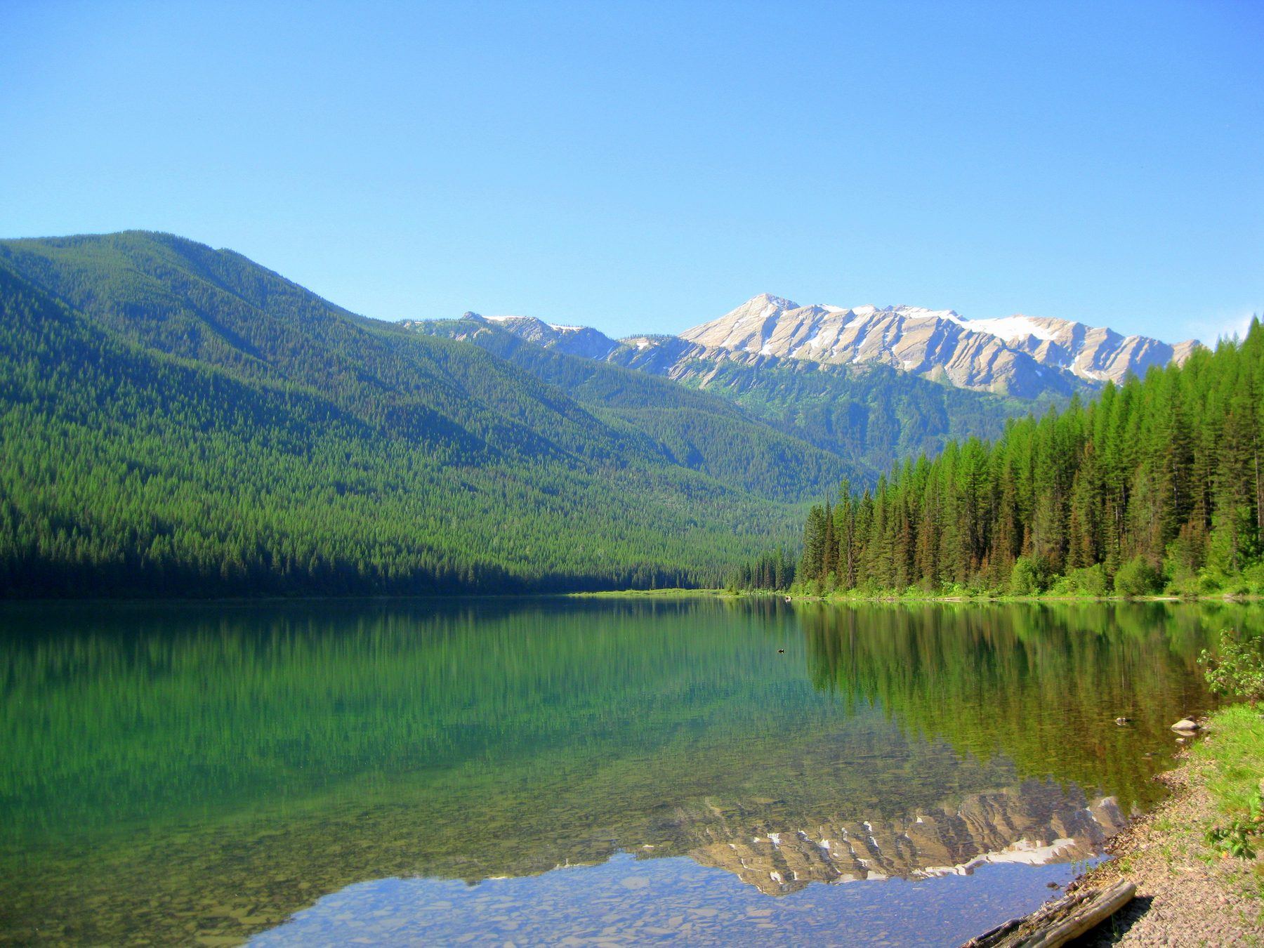
The reason to make the short climb is waiting at the top: a clear, cold, green-tinted lake sitting almost directly beneath Great Northern Mountain. At 8,705 feet, Great Northern is the highest point in the Great Bear Wilderness, and from the north end of Stanton Lake its upper slopes are close enough to feel immediate rather than distant, with pale rock bands and lingering snow visible well into summer. The mountain’s Stanton Glacier sits in a cirque on its upper flank, and its meltwater is a real contributor to the creek and lake system below — a large part of why the water at Stanton Lake stays as clear and cold as it does, even after weeks of warm weather.
The lake itself is small enough to take in from a single vantage point without much walking along the shore, ringed by conifer forest that comes right down to the waterline in most places. Color shifts with light and season — a deep green in full sun, flatter and more gray-blue under cloud — but the clarity is consistent, a function of cold water and a glacial source rather than any particular weather pattern. Forest cover along the shoreline muffles the sense of the highway you just left behind, and the combination of still water, close mountain, and quiet air is a fairly dramatic payoff for a walk this short.
Wildlife along the trail and around the lake is typical of a well-used Montana forest corridor — regional guides describe sightings as fairly common, without any single animal being the specific draw here the way Great Northern Mountain is. Standard backcountry sense applies: keep food secured, stay aware, and don’t expect the animals here to be habituated to people the way some more heavily developed trailheads can produce.
Access from Highway 2 and from Flathead Lake
Getting to the trailhead itself is close to as simple as trail access gets in this part of Montana. It sits directly on U.S. Highway 2, on the north side of the road, roughly 15 to 17 miles east of West Glacier — accounts differ slightly on the exact mileage, but the landmark to watch for is consistent: Stanton Creek Lodge, with the trailhead turnoff right around it. The parking area is small, with room for roughly a dozen vehicles, and it can fill during peak summer weekends given how visible and easy the pull-off is from a highway that carries steady Glacier-bound traffic all season.
From the north end of Flathead Lake, the drive follows the same general route this site describes elsewhere for reaching West Glacier — north up through Columbia Falls and onto U.S. Highway 2 — and then simply continues another 15 to 17 highway miles past West Glacier itself. All in, that’s roughly an hour and a half behind the wheel from the lake’s north shore, a bit more if you’re stopping for photos along the way, which makes Stanton Lake a realistic add-on to a day already built around a drive toward Glacier rather than a standalone destination worth a special trip on its own.
There’s no lake access, boat route, or shortcut into Stanton Lake from anywhere else — the highway trailhead is the only realistic way in, on foot, for the vast majority of visitors.
When to go and what to expect
June through October is the window most regional hiking guidance points to for a comfortable, snow-free visit, which lines up with the broader pattern across this part of the Flathead Valley and the mountains around it. Late spring, especially late May into early June, is workable but comes with caveats: lingering snow patches on shaded sections, soft mud lower down, and leftover winter deadfall across the trail that hasn’t been cleared yet. None of that makes an early-season visit a bad idea, but it does mean allowing more time and expecting rougher footing than a mid-summer trip would offer.
Midsummer is the busiest and most predictable stretch, both for weather and for trail traffic — this is also peak season for Highway 2 travel generally, with a steady flow of Glacier-bound visitors treating Stanton Lake as a worthwhile stop along the way. Fall brings cooler temperatures and, by several accounts, good color in the surrounding larch and deciduous trees, along with noticeably lighter trail traffic than the summer peak.
Stanton Lake is also described as a genuine year-round destination rather than one that shuts down once summer ends. A snowshoe or winter walk to a frozen, snow-rimmed lake is a real and reasonably popular option here, but it’s a different trip from the summer version in every practical sense — shorter daylight, colder exposure, and icy or snow-packed footing on that steep opening stretch that a summer hiker in trail shoes never has to think about. Anyone visiting outside the June-through-October window should plan and gear up for actual winter travel, not simply expect a quieter version of the same easy summer walk.
Frequently asked questions
How long is the hike to Stanton Lake?
Sources measure it a little differently, which is worth knowing before you go. Most trail trackers put the walk to the lake at somewhere between one and a half and two miles each way — call it three to four miles round trip — with the climbing concentrated in the first half-mile to mile before the grade eases off. Trail #146 itself actually runs longer than that, since it continues well past the lake toward higher ground used by climbers heading up Stanton Creek drainage, but that's a different, much more serious trip than the day hike to the shoreline.
How much elevation does the trail gain?
Reported figures for the lake segment range from roughly 250 feet to a bit over 700 feet, depending on the source and exactly where the measurement stops. What every account agrees on is where the effort happens: a steep opening stretch, then a trail that levels out and is close to flat for the final approach to the water.
Where is the Stanton Lake trailhead?
It's directly on U.S. Highway 2, roughly 15 to 17 miles east of West Glacier, on the north side of the road near Stanton Creek Lodge. The turnoff and small parking area are visible from the highway, though the lot is modest — space for a dozen or so cars — and can fill on summer weekends.
Is Stanton Lake a good hike for kids or beginners?
It's one of the more approachable trails along this stretch of Highway 2, short enough to fit into an afternoon and without any exposed scrambling. The catch is that first climbing stretch — steep enough to notice, especially for younger legs — before the trail flattens out for the rest of the way to the lake.
What mountain do you see from Stanton Lake?
Great Northern Mountain, at 8,705 feet the highest point in the Great Bear Wilderness, rises directly beyond the lake's far shore. Its Stanton Glacier sits in a cirque on the mountain's upper slope and feeds the lake below with meltwater, which is part of why the water reads so clear and cold even in mid-summer.
Is Stanton Lake inside Glacier National Park?
No, and this is a common mix-up given how close the two are. Stanton Lake sits in the Flathead National Forest, on the edge of the Great Bear Wilderness, on the south side of Highway 2 — directly across the corridor from Glacier National Park rather than inside its boundary. Different agency, different rules, no park entrance fee involved.
When does the trail become snow-free?
June through October is the reliable window most local guidance points to. Late May and early June are workable but can still have lingering snow patches, mud, and downed deadfall left over from winter, so budget extra time and expect the trail to feel rougher than a mid-summer visit.
Can you visit Stanton Lake in winter?
Yes — it's described as popular with snowshoers and winter walkers year-round, not just a summer destination. A frozen, snow-covered Stanton Lake is a genuinely different trip from the summer version, with shorter daylight, icy footing on that opening climb, and none of the trailhead crowding, so it rewards being prepared for winter travel rather than showing up in trail runners.